 The following excerpts are taken from Water Canada’s March/April 2013 article, “UNDERGROUND NETWORK – From sensors below the surface to satellites somewhere in orbit, groundwater monitoring is becoming more sophisticated”, by Erin Pehlivan.
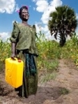 Helen Apio is filled with joy as she collects clean water in her Northern Uganda village. When she didn’t have water, she would walk to the nearest well—2.4 kilometres away—and wait in line with hundreds of other women, clutching two empty five-gallon water cans, anticipating stock.
 Charity: water has helped women like Apio by introducing a unique water technology that detects groundwater in developing countries. Founded in 2006, charity: water’s first project was to install six wells in a Ugandan refugee camp. They bought a GPS for $100, took it to Uganda, visited each project location and plotted six points on Google Maps, making the information and images public on their website. Six years later, the charity has funded over 6,994 water projects in 20 countries serving over 2.5 million people with clean drinking water.
  They have recently been allocated US$5 million for a pilot project via Google’s Global Impact Award to develop remote sensor technology specifically for groundwater.
So far, the charity has mapped each of its water projects to see how they function in real-time. The remote sensor technology will help keep them posted on whether water is flowing at any of their projects, at any given time, anywhere in the world.
The efficient design of remote sensor technology means that individual community members don’t need to visit every project physically to ensure constant water flow. These sensors manage time, budgets and resources with ease, allowing more time to be spent analyzing the actual water sample itself in the lab.
Below the surface: While real-time technology is growing more common throughout the water industry, groundwater applications are scarce.
 Richard Kolacz, president of Global Spatial Technology Solutions Inc. (GSTS), observes smart sensor capabilities that connect to groundwater sensors in Canada, allowing people to collect information from the sensors remotely.
![]() One Ontario conservation authority is already using one of GSTS’s water sensor prototypes on site. Initially, conservation authorities collected information manually. Now they’re able to collect it remotely. “We’ve developed an interface – a means of connecting to a groundwater sensor— to collect information in a format that the conservation authority likes,” says Kolacz. “Rather than waiting six months or more to collect data, they could have it back instantly.”
One Ontario conservation authority is already using one of GSTS’s water sensor prototypes on site. Initially, conservation authorities collected information manually. Now they’re able to collect it remotely. “We’ve developed an interface – a means of connecting to a groundwater sensor— to collect information in a format that the conservation authority likes,” says Kolacz. “Rather than waiting six months or more to collect data, they could have it back instantly.”
 The data coming from groundwater sensors to conservation authorities allows them to monitor water quality and quantity, and helps them understand the health and use of the water.
What’s so important about monitoring water data? The data could help First Nations communities in northern Ontario, according to Kolacz. “We would have the ability to monitor key data points on potentially clean or waste water treatment plants, and provide opportunities to monitor the health and status of those facilities remotely,” he says.
Much like charity: water, the difficulty with GSTS’s prototype comes from having to train staff to manage facilities. The data still has to be analyzed, and the quality of that analysis depends upon a certain level of knowledge.
Please note: I found the following YouTube video, published on Mar 27, 2013, that is directly related to the above information. Mr. Kolacz speaks about GSTS’s most recent application regarding goundwater monitoring. His presentation dealing with this topic runs from 3:20 to 7:30 on the video:
https://www.youtube.com/watch?feature=player_embedded&v=tEIb4z3YFe0#at=237
 Meanwhile, charity: water’s goal is to develop and install 4,000 low-cost remote sensors in existing and new water projects globally, all of which will transmit real-time data to the charity, its partners, and eventually to donors via status updates. Canada can learn from this model. According to the 2010 Review and Assessment of Canadian Groundwater Resources, Management, Current Research Mechanisms and Priorities by the
![]() Canadian Council of Ministers of the Environment, practitioners in the field need access to organized groundwater data. With projects like the ones charity: water and GSTS are piloting, that access can skyrocket.
Canadian Council of Ministers of the Environment, practitioners in the field need access to organized groundwater data. With projects like the ones charity: water and GSTS are piloting, that access can skyrocket.
 Groundwater is a valuable resource, but it is poorly understood and expensive to investigate. Incentives to effectively manage the resource are low. But respondents of the aforementioned review demand significant effort from the provincial government databases to provide up-to-date groundwater information accessible online. And once we embrace the new insights of cloud-based collaboration and networked sensor arrays, science-based policy will develop and advance, leading to more responsible water resource management and investments – especially when it comes to the murky and mysterious water that flows beneath us. Erin Pehlivan is a Toronto-based writer.
Related links ~
http://www.nrcan.gc.ca/earth-sciences/geography-boundary/remote-sensing/geospatial/1196
for Charity:water ~ http://washfunders.org/Blog/(offset)/30